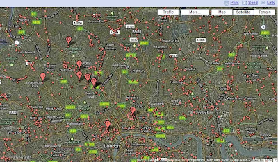
What would like to do today is talk you through how I think I have solved a problem of obtaining some of my data about the characteristics of place. It is with help of Google and it starts with a Google search. In this case I want the co-ordinates of all public houses or bars in the London Borough of Camden so that I can plot them along with other datasets. I reason that alcohol is a major cause of disorder and people being victims of crime. Also location of pubs and bars tend to indicate entertainment venues where people congregate. It would be nice to have every single pub and bar but for my purpose clusters are really what I am looking for. Of equal importance is where pubs and bars are not. A Google search using the "map" option for "Camden public houses" generates the map below.

Each of the red dots purport to be a public house. There are two problems to be overcome. Firstly, it seems that anyone can add a marker to this map- so accuracy is an issue, though most appear to have come from review sites or business advertising listings such as Thompson's local. Secondly the source code behind this map does not allow access to the co-ordinates of the red-dots.
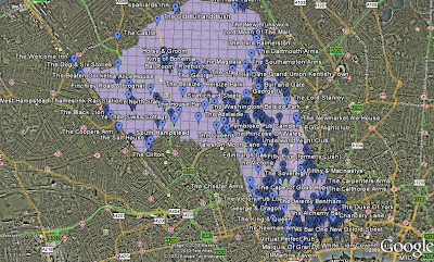
 There is a solution to both problems. Google allows users to create their own maps by clicking on "my maps". The map display remains the same but two important options become available. Firstly when you double click on a red dot or any other feature a dialog box appears as normal with information and usually a small picture, but now you have an option of pinning your own marker and retaining the name of the red dot. By going through this process and checking, where necessary, with Google Streetview a list of your own locations can be created. Secondly the option of "View in Google Earth" appears. This allows a .kml file to be created from the personalised layer you have made. This can be opened in Google Earth to display the markers there as shown below. This picture also shows another layer of the clipped Camden Borough grid that I created and converted to .kml file in ArcGIS

The clever thing is that within the "my maps"
kml file there are the names and co-ordinates of the public houses I have marked. The way in which I extract this information is simple. I create a .
xml file by renaming the .
kml file (just replace k with x). This allows the file to be opened by MS Excel. A little bit of
formatting and deleting allows a .
csv file to be saved that can be loaded into
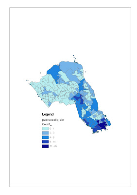
ArcGIS to create the maps below after a spatial join.
 Locations of Public Houses and Bars in the London Borough of Camden shown within Grid Cells

The Location of Public Houses and Bars in the London Borough of Camden shown with Lower Super Output Areas
I have deliberately left the dots of pubs and bars just outside Camden showing. Firstly to remind me that the projection of the grid and the dots are out by about 30 metres due to the use of different co-ordinate systems - I need to learn how to solve this. And as the borders of boroughs often follow historic main roads where pubs are located this is important. It also reminds me that the potential influence of a pub on crime and disorder is greater spatially than its actual location.
I have demonstrated the process with one set of relevant data. I now have access to the Google Data warehouse for my domains.
 Each of the red dots purport to be a public house. There are two problems to be overcome. Firstly, it seems that anyone can add a marker to this map- so accuracy is an issue, though most appear to have come from review sites or business advertising listings such as Thompson's local. Secondly the source code behind this map does not allow access to the co-ordinates of the red-dots.
 The clever thing is that within the "my maps" kml file there are the names and co-ordinates of the public houses I have marked. The way in which I extract this information is simple. I create a .xml file by renaming the .kml file (just replace k with x). This allows the file to be opened by MS Excel. A little bit of formatting and deleting allows a .csv file to be saved that can be loaded into ArcGIS to create the maps below after a spatial join.
 Locations of Public Houses and Bars in the London Borough of Camden shown within Grid Cells
google earth uses the WGS84 datum/projection http://earth.google.com/support/bin/static.py?page=guide.cs&guide=22373&topic=23750
ReplyDeletethis should be one of the default coordinate systems available in ARC. I imagine you are using NAD 1983 if the points are off by around 30 meters. There may be custom arcscript extensions for importing kml files directly
http://arcscripts.esri.com/
Thanks Andy, very helpful.
ReplyDeleteOpenStreetMap probably has pretty comprehensive coverage of bars in central London, i.e. including Camden borough. If there's one thing that London OSMers like adding, it's amenity=pub.
ReplyDeleteYou can extract names and locations of pubs in the OSM database, for the general area by doing a query using the XAPI service, then crop by the boundary in your GIS application of choice.
Try: http://xapi.openstreetmap.org/api/0.6/node[amenity=pub][bbox=-0.22,51.51,-0.10,51.58]
You'll then need to convert this data from the OSM XML format into something more GISy using something like osm2shp or osm2gml - alternatively some GISes, e.g. Quantum, now have plugins that allow direct reading of OSM-format files.
Thanks, Ollie I will look into it
ReplyDeletehey nice source for us,thanks for sharing the amazing information of the extract the data from the google maps and this information really helpful for me and these pics that you are posting in the blog is very nice and provide the good ideas of how to extract data from google maps.
ReplyDeleteGoogle Maps Data Extraction